Opportunities in Glacier InVEstigation
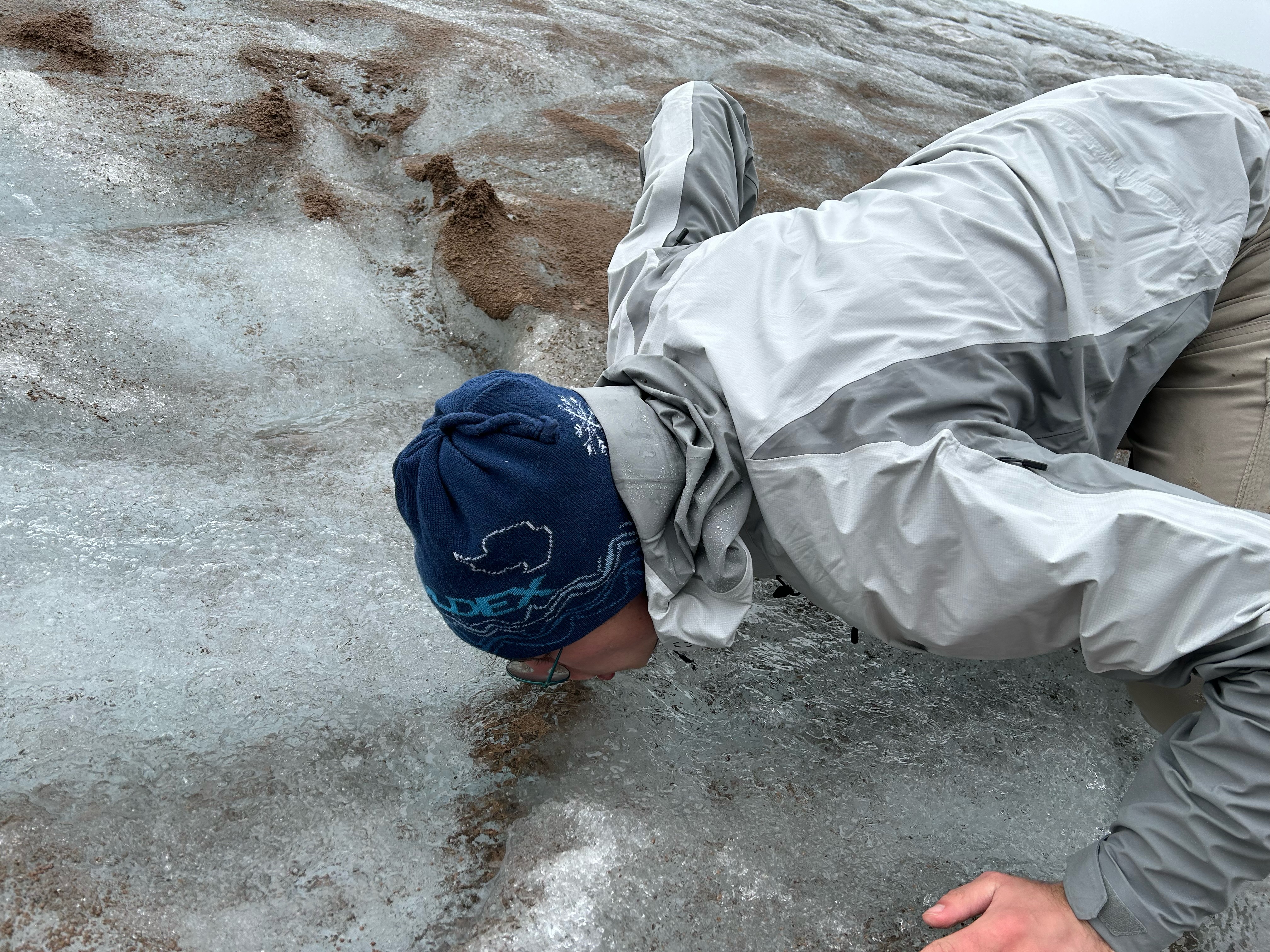
OGIVE – definition: annual bands visible in some glaciers below an ice fall
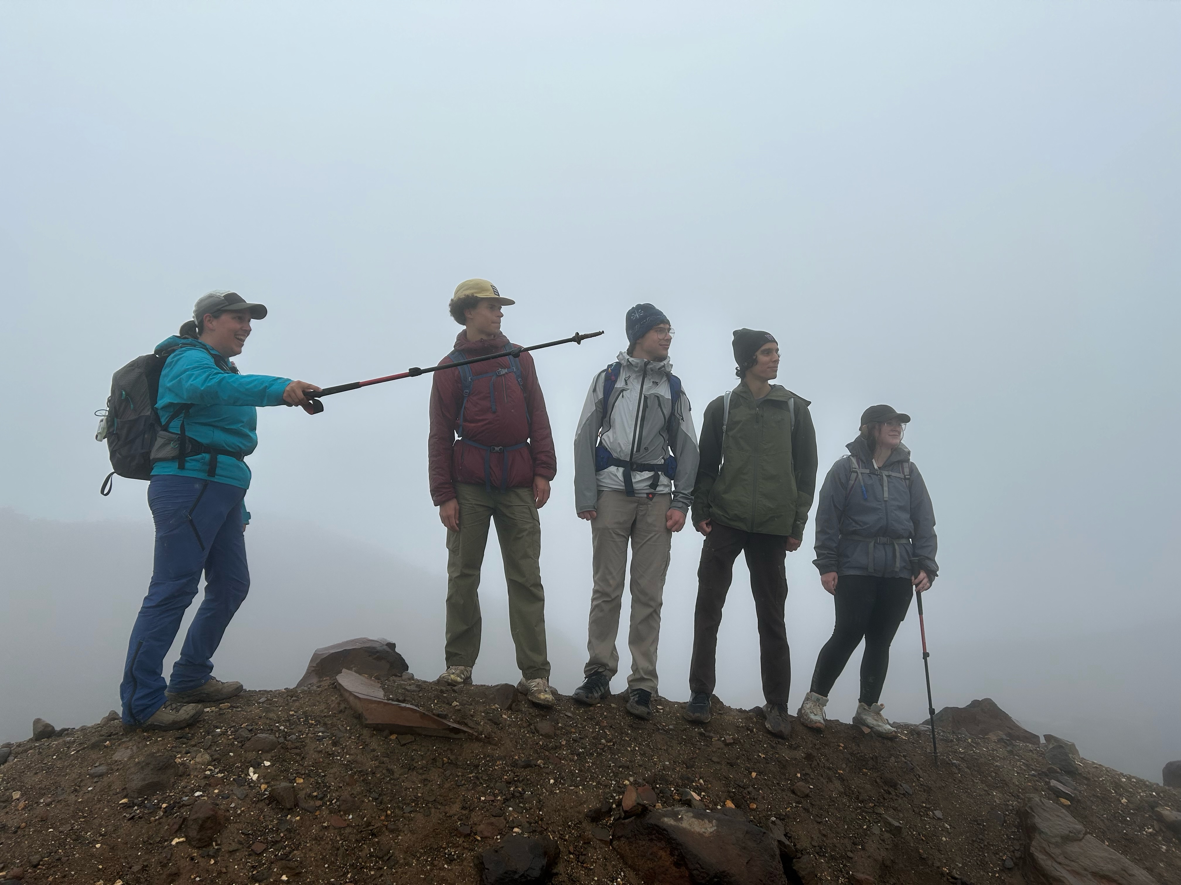
OGIVE – acronym: Opportunities in Glacier InVEstigation is an summer research program of the glaciology group at University of Washington. OGIVE provides summer research opportunities for undergraduate students at University of Washington.

The summer of 2021 was the first phase of increasing the number of undergraduate participants and graduate student mentors. Four undergraduate participants, three graduate student advisors, two faculty advisors, and many more graduate and faculty collaborators participated. Through a generous private donation, the program will be expanded in the follow years to include more undergraduate student projects, more project and mentoring development, and more field experiences. Exciting details to come.
2023 Students and Projects
Advik Eswaran: Late 20th-century increase in Antarctic snow accumulation drives modest sea level mitigation
Faculty Advisor: T.J. Fudge
Increasing Antarctic snow accumulation can mitigate sea level rise, but there is considerable uncertainty around both past snowfall trends and future projections. Here, we present an ice core-based reconstruction of Antarctic accumulation using the Last Millennium Reanalysis, an established paleoclimate data assimilation framework. Utilizing ice core water isotope and accumulation records and an ensemble of multiple CMIP5 climate model simulations, we produce annually resolved rec onstructions from 1801-2000 CE. The reconstructions demonstrate significant skill through strong satellite-era (1981-2000) correlation with instrumental reanalyses and alternate proxy-based reconstructions; significant skill improvements are especially found in uncertain, low-accumulation regions far from existing proxy sites (e.g. the East Antarctic Plateau). Reconstructed trends indicate a positive trend in Antarctic accumulation over the 20th century (0.4 Gt yr-2 from 1901-2000), with a further acceleration in the late century (1.1 Gt yr-2 from 1957-2000). The increase in accumulation translates to a total sea level mitigation of ~1 mm from 1901-2000, driven by a significant continent-wide rise in mitigation beginning around 1970 (0.7 mm dec-1 from 1970-2000). Our estimates of consistently increasing West Antarctic sea level mitigation broadly agree with previous studies. However, we find a much smaller magnitude of continent-wide sea level mitigation: a discrepancy attributable to divergent estimates of accumulation trends in East Antarctica.
Noah Brown: Optimizing a Continuous Flow Analysis (CFA) System for Water Isotope Research
Grad Student Advisor: Lindsey Davidge
Faculty Advisor: Maciej Sliwinki, Eric SteigWater isotopes from ice cores are an important proxy for reconstruction of Earth’s past climate. A continuous flow analysis (CFA) system provides precise, high resolution, water isotope data by vaporizing meltwater and measuring the vapor via laser absorption spectroscopy. The goal of this research is to optimize a CFA system based on the previously published systems of Jones et al. 2017 and Davidge et al. 2022, which were in turn outgrowths of Gkinis et al. 2010. For our analysis of the system’s performance, we use VSMOW-SLAP calibrated reference waters to assess performance. An optimized system should produce an isotope signal that is stable and without significant drift over the duration of a typical analysis day (i.e., 12 hours of nighttime reference water measurement followed by 12 hours of ice core measurements). Additionally, the memory effect, which is a smoothing of isotope signals as sample water moves through the CFA system, should be rigorously characterized and minimized for proper back-correction. Results show no functional impact on memory and stability when using metal versus a glass nebulizers as part of vaporization. However, the metal nebulizer is far easier to maintain, tune, and reconfigure.
Aidin Dealy: Roughness of Antarctic Ice Shelves from IceSat 2Grad Advisor: Steph Olinger
Faculty Advisor: Brad Lipovsky
Understanding the dynamics of the Antarctic Ice Sheet (AIS) is critical as global temperatures increase and sea level continues to rise. Ice shelves stabilize the AIS, regulating the flux of grounded ice into the ocean. Ice shelf collapse destabilizes grounded glaciers, leading to rapid ice loss and an increase in the local contribution to sea level rise. Sparse observations have limited our understanding of ice shelf collapse, but newly-available satellite altimetry data offers the potential to monitor ice shelf structural integrity from space. Here, we use ICESat-2 altimetry data to characterize surface morphology of Ross and Pine Island Glacier Ice Shelves, as well as Conger Ice Shelf, which collapsed on March 15th, 2022. Following Watkins, Bassis, and Thouless (2021), we compute the power spectral density (PSD) between 90 and 3000 m wavelengths for each ice shelf’s surface topography. We also compute roughness values of each shelf, where roughness is defined as the square root of the integrated PSD. We find that Pine Island Glacier and Conger Ice Shelves have significantly higher magnitude PSD than Ross Ice Shelf at all computed wavelengths, with total roughness values almost two orders of magnitude higher. This is consistent with our expectations based on satellite imagery and ICESat-2 elevation profiles. To investigate whether the collapse at Conger Ice Shelf was associated with progressive structural changes, we compare topographic profiles recorded in 2020 and 2021. We do not observe any significant increase in roughness over the study period, suggesting that the collapse was a response to transient forcing and not gradual structural degradation related to surface roughness.
Cody Cruz: Experiments and Modeling of Hydraulic Fractures in Briny Ice
Grad Student Advisor: JM Manos
Faculty Advisor: Brad Lipovsky
Mechanical differences between saltwater and freshwater ice are known to induce distinct fracture behavior. For example, McGrath et al. (2014, J. Geophys Res.) observed that saltwater accreting to the bottom of ice shelves slows rift propagation. The stability of ice shelves is extremely important to deep water formation and global climate processes. In part, the dampening effect of salinity on fracture may be due to the heightened hydraulic diffusivity of saline ice; channels formed during brine rejection provide pathways for expelling pressurized water that might otherwise stress the ice to the point of brittle failure. In order to better understand the relationship between salinity, temperature, and fracture in ice, we performed experiments exploring the hydraulic diffusivity of small, briny ice samples. Performing 48 iterations of our experiment, we subjected 950mL water samples of varying salinities to a range of sub-freezing ambient temperatures.
In a typical experiment, after most of the sample was solid, the center-bottom bulged out before developing fractures as it froze. Samples with higher salinities, as well as those subjected to warmer temperatures, likely attained lower pressures, exhibiting less bulging and fracture. We attribute this behavior to the fact that pressurized water within the more saline samples was able to exit through brine channels before the critical level needed to induce fracture was reached. We support this interpretation with an analytic model in which an outer sphere of ice encroaches on an inner sphere of liquid, with increasing pressure as a function of decreasing liquid sphere radius. Our results demonstrate a strong relationship between salinity, temperature, and fracturing. Our study therefore provides insights into the underlying, small-scale physical processes involved in the observed marine ice stabilization of ice shelf rift propagation.
Eads Fouche: Understanding Ice Flow and Deformation in the Allan Hills Through Satellite Imagery, Tephra Layers, and Steepest Flowlines
Grad Student Advisor: Margot Shaya
Faculty Advisor: T.J. Fudge
The Allan Hills, Antarctica, is a unique location where ice over a million years old is located close to the surface, enabling the collection of multimillion-year-old ice cores. While the surface sublimation and complex bed topography helps uplift million-year-old ice, folding disturbs the continuity of ice with various ages, resulting in a complex, vertical depth-age profile. Previous drilling at the Allan Hills, ALHIC1901, reveals how 2-3 Ma ice is interspersed with 0.5 Ma ice, complicating the identification and collection of a continuous multi-million-year-old atmospheric history.
In this work, we use satellite imagery, GPS velocity measurements, and digital elevation models to improve our understanding of the complex ice flow in the Allan Hills, with the end goal of informing future ice core drilling efforts. We identify and map the surface exposure of tephra layers, which deform with ice flow. We show that flowlines that follow the surface gradient do not match observed horizontal velocities, suggesting that ice flow in the Allan Hills is a product of more than just the gravitational driving stress. By comparing tephra ages and the strike and dip of exposed tephra layers, this research aims to clarify the near-surface age structure of the ice, an important constraint for future modeling of the preservation and distribution of old ice. In addition, we have created a shareable, QGIS map with interactive layers for the data sets analyzed—ice core locations, radar profiles, GPS stakes, and tephra layers. By doing so, this project contributes to a better shared understanding of the Allan Hills glacial history and locally collected ice core record.
Jamie O’Reilly: Identifying True Dip of Layering in Large Diameter Ice Cores: A Novel Approach Using Multi-Track ECM
Grad Student Advisor: Liam Kirkpatrick
Faculty Advisor: T.J. Fudge
The Allan Hills is a blue ice area east of the Transantarctic Mountains where ice up to 4 million years old has been recovered. This very old ice is not part of a continuous climate record and has a complicated transport and deformational history. Due to the discontinuity and complicated nature of this ice, the age of the ice can neither be considered to increase with depth or be considered constant across the width of the core. New drilling technology has allowed 9-inch diameter ice cores, compared to the typical 4-inch diameter cores for deep coring projects, to be collected from this area. Imaging of the ice core stratigraphy is important for the climate interpretation of these cores.
Here we present a novel method of inferring the true dip of the layering in ice cores using multi-track electrical conductivity measurements (ECM) applied to AC and DC ECM data from three sections of the ALHIC1903 core. The measurements span from 74.87 m to 76.88 m in depth, with an age of approximately 125 thousand years. These measurements were taken in tracks across the core in increments of 10 mm spacing on two faces: the full width of the core when split in two, and then the width of one quarter of the core, which is perpendicular to the full width face. We found that layering in the cores is observable and measurable using ECM. We identified the layers using the individual plots of both the AC and DC conductivity measurements to find the local maximum and minimum conductivity. Being able to identify the relative depth of the conductivity peaks and throughs across the multiple tracks allows for the calculation of a layer dip in a single plane. Combining the measurements on the perpendicular faces allows the true dip of the layer to be determined. Because ECM allows for nondestructive data collection, the measured ice is still available for future climate data collection. The sampling plans for this future work will be informed by our characterization of internal layering within the core.
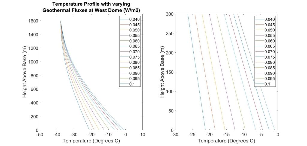
Marc Sailer: Modeling atmospheric gas diffusion for ice core site selection between the South Pole and Dome A
Faculty Advisor: T.J. Fudge
Extending the ice core record beyond 800 kyr requires not only finding ice of that age, but ice that preserves the paleoclimate records of interest. Thus it is also important to understand whether and how the atmospheric gases and other proxies we measure in the ice are preserved . As ice ages and is buried and flows deeper in the ice sheet, it thins and is subject to warmer temperatures. This causes both the gradient of gas signals to increase as well as increasing the diffusivity of gases in the ice, resulting in regions where the measured gas concentration values in the ice may not accurately represent the atmospheric composition at the time of deposition. In this study, we model diffusion of two atmospheric gases, CO2 and the δO2 /N2 ratio (because O2 diffuses more rapidly than N2, we only model O2). We focus on the region between the South Pole and Dome A where airborne geophysical surveys are being conducted for COLDEX.
We use a 1D, steady state model to calculate the ice temperature and age with relation to depth. We vary four input parameters: 1) ice thickness, 2) surface temperature, 3) accumulation rate and 4) geothermal flux. The temperature and thinning histories then force a model of gas diffusion allowing the change in gas concentration with age to be determined. Old ice layers in regions of low accumulation are thicker at depth than layers in regions of high accumulation, which results in smaller gradients when diffusivity is high in the warm ice at the bottom of the ice sheet. Geothermal flux influences the temperature deep in the ice sheet, with higher geothermal flux and temperatures increasing the diffusivity of gases and potentially melting the old ice away. The effect ice sheet thickness has on diffusion is largely determined by the geothermal flux because of how ice insulates heat released from the bed. The surface temperature varies relatively little in the study area and has a weaker effect. These results will help select drill sites by identifying locations more likely to preserve the climate records of interest.
2022 Students and Projects
Advik Eswaran: Identifying Promising Antarctic Ice Core Sites using Synthetic Records and Data Assimilation
Faculty Advisor: T.J. Fudge
Project Description: Ice cores record information about the past climate, with the two primary markers being water isotope ratios as a proxy for temperature and snow accumulation. The drilling of ice cores, however, is controlled by external constraints such as climatic setting, ice-sheet characteristics, and logistical constraints. A new ice core site ideally would have water isotope and accumulation records that improve the skill of paleoclimate reconstruction as much as possible. This project analyzes which ice core sites would do so best. We start with the Last Millennium Reanalysis (LMR), a proven climate reconstruction framework that uses the ensemble Kalman filter. We compile all existing Antarctic water isotope and accumulation data and assimilate it into LMR, with the resulting temperature anomaly reconstructions showing a highly skilled baseline that closely matches ERA5 reanalysis. We use two measures of skill: the absolute difference between LMR’s predicted anomalies and ERA5’s reanalyzed anomalies for each year, and the correlation between the two over the full time series. We then plan to create synthetic proxy records for various locations currently lacking ice cores, drawing from existing temperature reanalysis with artificially added noise. We will then assimilate these synthetic records into LMR along with the actual records, noting the skill improvement from the baseline. Finally, we will evaluate those locations that showed the greatest gain in skill according to external and logistical constraints.

Example of a LMR-predicted temperature anomaly (K), for 1998 relative to 1951-1980
Aidin Dealy: Roughness of Antarctic Ice Shelves from IceSat 2
Grad Advisor: Steph Olinger
Faculty Advisor: Brad Lipovsky
Understanding the dynamics of the Antarctic Ice Sheet (AIS) is critical as global temperatures increase and sea level continues to rise. Ice shelves stabilize the AIS, regulating the flux of grounded ice into the ocean. Ice shelf collapse destabilizes grounded glaciers, leading to rapid ice loss and an increase in the local contribution to sea level rise. Sparse observations have limited our understanding of ice shelf collapse, but newly-available satellite altimetry data offers the potential to monitor ice shelf structural integrity from space. Here, we use ICESat-2 altimetry data to characterize surface morphology of Ross and Pine Island Glacier Ice Shelves, as well as Conger Ice Shelf, which collapsed on March 15th, 2022. Following Watkins, Bassis, and Thouless (2021), we compute the power spectral density (PSD) between 90 and 3000 m wavelengths for each ice shelf’s surface topography. We also compute roughness values of each shelf, where roughness is defined as the square root of the integrated PSD. We find that Pine Island Glacier and Conger Ice Shelves have significantly higher magnitude PSD than Ross Ice Shelf at all computed wavelengths, with total roughness values almost two orders of magnitude higher. This is consistent with our expectations based on satellite imagery and ICESat-2 elevation profiles. To investigate whether the collapse at Conger Ice Shelf was associated with progressive structural changes, we compare topographic profiles recorded in 2020 and 2021. We do not observe any significant increase in roughness over the study period, suggesting that the collapse was a response to transient forcing and not gradual structural degradation related to surface roughness.

Amanda Saymsul: Calculating Cascadia subduction zone slip due to glacial loading
Faculty Advisor: Brad Lipovsky
Post-glacial rebound is the Earth’s response to the retreat of ice sheet retreat, thus, models of this process have been used to constrain post-glacial sea-level change. The post-glacial rebound uplift of Cascadia has been ongoing as a result of the decay of the Cordilleran ice sheet that has covered large parts of North America over the last ~2.6 million years. Models of glacial isostatic adjustment in the northern cascadia subduction zone are able to match rapid land uplift during glaciation, but require unusually low upper mantle viscosities. Hetzel & Hampel (2005) showed that lithospheric rebound caused by the regression of Lake Bonneville and deglaciation provides a possible mechanism for the high rates of faulting in the Wasatch region during the Holocene
(Figure 1). Adjacent to their work, this ongoing project aims to calculate the slip of the Cascadia subduction zone due to glacial loading in an idealized model. To evaluate the predicted behavior of a the Cascadia megathrust fault during glacial loading and unloading, we aim to design a finite-element model, which incorporates its thrust fault, to investigate the possibility that some of the land uplift following deglaciation was accommodated by motion along the subduction zone-megathrust interface. This project is still in the early stages of development.

Anjali Manoj: Glacial Insights from Alcoves in the Deuteronilus Mensae Region of Mars
Graduate Advisor: An Li
Faculty Advisor: Michelle Koutnik
Deuteronilus Mensae (40ºN-48ºN, 16ºE-35 ºE) is a region in the mid-latitudes of Mars that has landscapes with remnants of past glaciations as well as with recent radar studies showing presence of subsurface ice.
In this study, we focus on alcoves found along mesas in the region with the goal of studying their characteristics and the erosional processes that formed them, whether glacial or otherwise. We mapped out 1952 alcoves using Context Camera (CTX) images and High Resolution Stereo Camera (HRSC) digital elevation models. The alcoves were classified into 7 classes – 4 related to glacial processes and 3 related to other processes such as fluvial and crater impact. Subcategories were used to determine the type of material, if any, present in the alcoves.
We then drew our focus to those alcoves that had High Resolution Imaging Science Experiment (HiRISE) data available in order to study the alcoves at a higher resolution. We used digital elevation models made from CTX and HiRISEto produce geomorphic maps of the alcoves. In our preliminary observations from the mapping, we see distinct debris types such as layers, blocks, boulders and possible moraines found in certain alcoves in the simple and complex classes. We will then perform high resolution comparisons between the different alcoves including comparing slopes, thickness of layers, occurrence of boulders and volume of blocks to see what can be inferred about the processes that shaped these alcoves and if there is evidence for their glacial origin.
Through these investigations into the alcoves and the processes that shaped them, we aim to further our understanding on how alcoves on Mars may be categorized based on their features and what can be inferred about their origin. In doing so, we may be able to learn more about the glacial processes that shaped the Deuteronilus Mensae region.

Fig1: Geomorphic map of an alcove
Cody Cruz: Temperature Amplitude and Isotope Diffusion in Firn
Faculty Advisor: T.J. Fudge and Andy Schauer (Isolab)
Firn is the layer of snow compacting into ice at the surface of glaciers. The firn densifies to ice at ~120 m depth at the South Pole, with an age of 1000 years. The water isotope record of deuterium and oxygen-18 can be used in two ways to infer past temperature: 1) the traditional method associating a concentration of heavier isotopes with warmer temperatures and 2) an emerging method which uses the amount of diffusion the water isotope records have experienced. The primary question this project explores is how a change in the amplitude of the seasonal temperature cycle—but with the same mean temperature—affects the amount of diffusion in the water isotope record. We use the Community Firn Model (CFM) to explore this question. Creating input files for constant snow accumulation and sinusoidal atmospheric temperatures and isotope concentrations—to roughly simulate South Pole conditions—the CFM models the firn column for 1500 years to track isotope diffusion with depth. The model is forced at monthly time steps with constant accumulation, a fixed seasonal cycle for the water isotopes, and three amplitudes of the seasonal temperature cycle: 10,20, and 30°C from a mean of -50°C. The hypothesis was that greater amplitudes of seasonal temperatures would result in more diffusion. However, current model results only support this for the first ~100 years of diffusion and the rest of the firn column yields negligible difference due to atmospheric temperature amplitude. As firn is porous, densification occurs in air, increasing the complexity of interaction. One possibility is the effect on diffusion rates by firn temperature and tortuosity: perhaps increasing density and firn temperature fluctuations control diffusion more than initial surface temperatures. The model results will be used to interpret water isotope measurements from South Pole firn which are currently being processed at the UW IsoLab.

CFM isotope diffusion results. For both isotopes, the larger the seasonal temperature amplitude, the quicker diffusion occurs in the firn, averaging out the isotope values. Note that at around 100 years, the Lesser and Medium Temperature Amplitude diffusions catch back up to the Greater Temperature Amplitude diffusion
Jonathan H. Ortiz-Candelaria: Understanding Ice Temperature in Ice Streams in Antarctica and Greenland
Graduate Advisor: Ben Hills
Faculty Advisor: T.J. Fudge
The goal for this project is to understand temperature flow in glaciers throughout ice streams around Antarctica and Greenland. Specifically, the changes caused in temperature flow due to a glacier being transported downstream. As is known, the higher in elevation and more upstream a glacier is, the colder its overall temperature is along with the climate. This cold air and temperature in ice gets transported downward as it flows through the ice stream. This has different effects on the ice depending on the initial temperature, but most commonly it just makes ice temperatures colder. What we’re trying to understand is if this downstream temperature truly matters in the whole scheme of temperature flow. Usually, this downstream or longitudinal temperature flow is neglected due to the belief that it is a small change which makes it negligible. The issue that arises with this though is that when temperature predictions are compared to measured temperatures, there is a sizable difference. This sizable difference might just be caused due to the dismissal of longitudinal temperature flow. This is why this project aims to graph and analyze surface temperature, accumulation, and ice thickness data which contribute to internal glacial temperatures. With these analyses, we can determine how important longitudinal temperature flow truly is.

Fig 1. Graphs and Data for Thwaites Glacier
Sarothi Ghosh: Controls on water isotopes in a WAIS collapse scenario
Graduate Advisor: Lindsey Davidge
Faculty Advisor T.J. Fudge
One uncertainty in paleoclimate research is the extent of Antarctic ice loss during the Last Interglacial Period (125ka-116ka), though retreat of the West Antarctic Ice Sheet (WAIS) is likely. Water isotope ratios (such as H218O/H216O, known as δ18O) in ice cores near the WAIS may reflect WAIS collapse conditions; one goal of the future Hercules Dome ice core is to recover a record of potential isotope changes due to WAIS collapse. However, it will be important to understand how and why changes in δ18O occur in response to WAIS ice loss. The goal of this project is to use a 1-D, zonally averaged climate model to simulate water isotope variations caused by WAIS collapse. Zonally averaged temperature and hydrologic flux information from the Community Climate System Model (CCSM4) are used as input for the simple model, in order to disentangle global and local influences on variations in the water isotope profile. By comparing results from the simple model with more detailed simulations from 3-D global climate models, we can gain insight into the dominant controls on δ18O variations during WAIS collapse. Ultimately, this will be important for understanding the Hercules Dome isotope record.

2021 Projects
Jennifer Lomeli (UW): Upper and lower bounds of geothermal flux at Hercules Dome, Antarctica
Graduate Student Advisor: Gemma O’Connor
Faculty Advisor: T.J. Fudge
Program: Washington Space Grant Summer Undergraduate Research Program
Project Description: The largest unknown for estimating internal ice temperatures and hence the temperature of ice at the bed is the geothermal flux – the amount of heat flow from the earth into the base of the ice sheet. This value is poorly known across all of Antarctica because of the sparsity of measurements. The goal of this project is to use geophysical indications of both frozen and melting at nearby locations with different ice thicknesses to constrain the geothermal flux. Ice flows differently near an ice divide due to the low stress, such that the shape of the vertical velocity can be diagnostic of a frozen bed. Subglacial lakes can be identified with radar by their smooth surface and specular reflection. The presence of subglacial lakes indicates a thawed bed. Hercules Dome has indications of both a frozen bed beneath the divide at relatively shallow ice thicknesses (~1600m) and a melting bed at a lake under thicker ice (~2400m), which are separated by tens of kilometers. The project will use an ice-and-heat flow model to find the range of geothermal flux values that produce both a frozen bed at shallow ice thickness and a melted bed with thicker ice. The goal is for the student to have: determine the range of geothermal flux values consistent with the basal thermal constraints; gained experience performing scientific research; gained experience reading, interpreting, and communicating about scientific literature; gained a general understanding of ice-core science; gained skills in coding in Matlab; and aided the climatic understanding of a future deep ice core site in Antarctica.
Raphael Sauvage (UW): Effective Diffusivity of Sulfate in the Dome C ice core
Graduate Student Advisor: Ben Hills
Faculty Advisor: T.J. Fudge
Program: Washington Space Grant Summer Undergraduate Research Program
Project Description: The goal of this project is to understand how the sulfate record, dominated by the volcanic signal, is altered through time. Ice core analysis has revealed that the sulfur signal diffuses with age (depth), but the diffusivity is not well constrained. It is also not clear what controls the process of diffusion. The Dome C core from interior East Antarctica will allow an improved analysis of the effective diffusivity because there are multiple glacial-interglacial cycles. By using the volcanic peaks identified in only similar climate periods (i.e. all interglacial periods or all glacial maximums), the variability in the deposition can be largely eliminated. The goal is for the student to have: determined the effective diffusivity of sulfate using multiple interglacial and glacial periods; gained experience performing scientific research; gained experience reading, interpreting, and communicating about scientific literature; gained a general understanding of ice-core science; gained skills in coding in Matlab; and aided the understanding of future deep ice core sites in Antarctica.
Alexis Irvin (University of Florida): Modern climate of Hercules Dome, Antarctica
Graduate Student Advisor: Annika Horlings
Faculty Advisor: T.J. Fudge
Program: Cooperative Institute for Climate, Ocean, Ecosystem Studies (CICOES)
Project Description: The goal of the project is to better understand the interannual variations in climate at Hercules Dome (-86S, 105W) a future deep ice core site. Determining how the accumulation rate over Hercules Dome has varied in space and time is therefore important for interpreting the ice core at Hercules Dome and for modeling past ice flow. The primary climate reanalysis used will be ERA5 monthly averages. Highly temporally resolved (up to daily) reanalysis data may be needed to analyze storm directions. The goal is for the student to have: produced images/animation of each year’s annual accumulation in ERA5 to allow a qualitative comparison with the accumulation measured with radar; performed correlations of climate variables; gained experience performing scientific research; gained experience reading, interpreting, and communicating about scientific literature; gained a general understanding of ice-core science and climate reanalysis; gained skills in coding in Matlab and analysis of climate reanalysis output such as ERA5; and aided the climatic understanding of a future deep ice core site in Antarctica.
Victoria Johnson (UW): Ice Quake Hunting at the West Antarctic Ice Sheet Divide
Faculty Advisor: Brad Lipovsky
Program: Earth and Space Sciences Undergraduate Research
Project Description: Ice flow is like a lot of mini earthquakes and makes a lot of seismic noise. Observing and interpreting that noise is a challenge. This project seeks to find ice quakes in a location – an ice divide – where we do not expect them because of the low ice velocities. This research will help determine if ice quakes are being misidentified in faster flowing regions. The goal is for the student to have: applied algorithms for identifying ice quakes in seismic data ; gained experience performing scientific research; gained experience reading, interpreting, and communicating about scientific literature; gained skills in scientific computing; and aided the understanding of processes controlling ice flow in Antarctica.
2020 Projects
Linh Vu (UW): Determining effective diffusivity of sulfate using volcanic event widths
Faculty Advisor: T.J. Fudge
Program: Washington Space Grant Summer Undergraduate Research Program
Project Description: The goal of this project is to understand how the sulfate record, dominated by the volcanic signal, is altered through time. Ice core analysis has revealed that the sulfur signal diffuses with age (depth), but the diffusivity is not well constrained. It is also not clear what controls the process of diffusion. Using multiple ice cores, the spreading of the average width of volcanic events will be used to place constraints on the effective diffusivity. The goal is for the student to have: determined the effective diffusivity of sulfate using multiple ice cores; gained experience performing scientific research; gained experience reading, interpreting, and communicating about scientific literature; gained a general understanding of ice-core science; gained skills in coding in Matlab; and aided the understanding of future deep ice core sites in Antarctica.
2019 Project
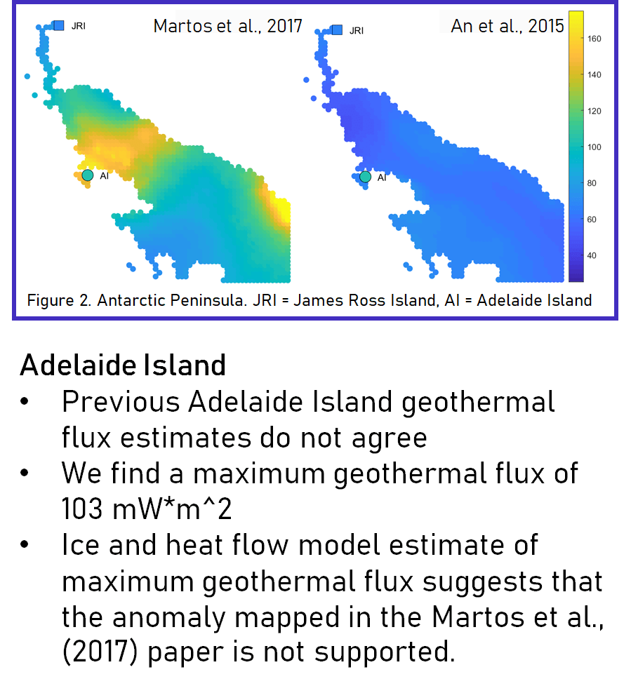
Elizabeth Urban (UW): Upper limits of geothermal flux from Raymond Arches observed around Antarctica
Faculty Advisor: T.J. Fudge
Project Description: Geothermal flux is an important input parameter for modeling the Antarctic Ice Sheet and estimating future sea level changes. High geothermal flux results in basalt melt of an ice sheet, which increases water flow and allows sliding. Direct measurements of geothermal flux in Antarctica are rare, as the ice-bedrock interface is buried under hundreds to thousands of meters of ice. Raymond arches indicate a coastal dome is frozen at the bed and is a site that can be used to calculate maximum geothermal flux. The maximum geothermal flux is estimated by inputting site-specific data of ice thickness, accumulation rate and surface temperature into an ice-and-heat flow model for coastal domes. When a basal temperature is also available, the geothermal flux can be calculated. Sixteen coastal domes were modeled in this project. Geothermal flux was calculated for four sites and maximum geothermal flux was calculated for twelve sites. These results are compared against two continent-wide models of geothermal flux, based off Curie depths and seismic wave refraction. On Adelaide Island, the continental models do not agree, and this site-specific model returns a value in between their geothermal flux estimates, which suggests that the greater geothermal flux estimate is too high. In Dronning Maude Land, the site-specific maximum geothermal flux values are regionally consistent and indicate what site characteristics produce significant results. Sites with greater ice thicknesses, lower accumulation rates, and warmer surface temperatures yield lower maximum geothermal flux estimates, which are more useful in constraining the geothermal flux.
2018 Project
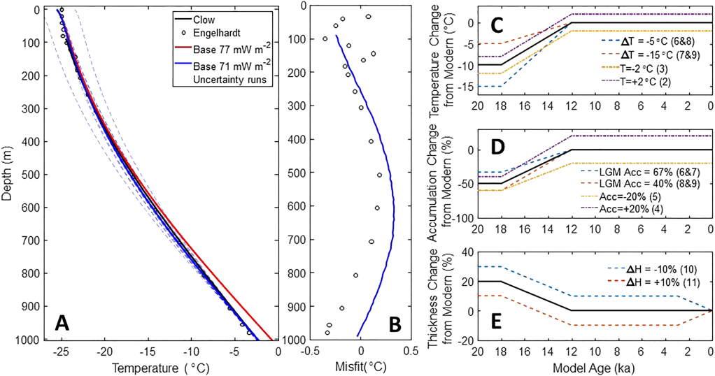
Surahbi Biyani (UW):
Constraining Geothermal Flux at Coastal Domes of the Ross Ice Sheet, Antarctica
Faculty Advisor: T.J. Fudge
Project Description:The geothermal flux is an important boundary condition for ice‐sheet models because it influences whether the ice is melting at the bed and able to slide. Point measurements and remotely sensed estimates vary widely for the Ross Ice Sheet. A basal temperature measurement at Roosevelt Island reveals a geothermal flux of 84 ± 13 mW/m2. The presence of Raymond Arches, which form only at ice divides that are frozen at the bed, allows inferences of the maximum geothermal flux at two coastal domes along the Siple Coast: Engelhardt Ridge, 85 ± 11 mW/m2 and Shabtaie Ridge, 75 ± 10 mW/m2. These measurements indicate heat flows similar to measurements at Siple Dome and the Whillans grounding zone and to the continental crust average. The high values measured at Subglacial Lake Whillans and estimated from satellite observations of Curie depths are not widespread.